Levelling-benchmarks
- Subheading: Use of Sille.space, City of Tallinn
Levelling-benchmarks Tallinn, Estonia
Case Background
The complementary use of satellite radar interferometry (InSAR) with traditional systems has been successfully applied in projects worldwide. The wide coverage and high density of information, provided remotely by advanced InSAR techniques, is not achievable with in-situ instrumentation. The historical satellite data provides a ground deformation baseline (e.g. identification of pre-existing ground movement).
Objectives
Commissioned by the city-planning office’s engineering department:
1. To validate and check the stability of the city’s official height network, on which key infrastructures such as buildings, roads, bridges, tunnels, water supply, sewers, and electrical grids are built.
2. To pinpoint height benchmarks that should be re-leveled
3. Highlight areas that need to be focused on and where benchmarks need re-leveling
Tallinn (Europe capital city) - Vertical movements 2016-2021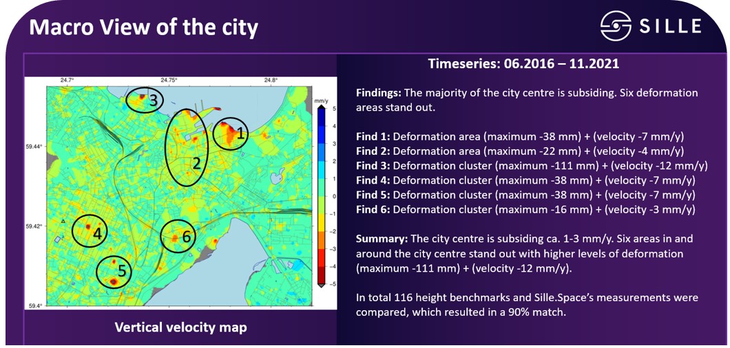
Leveling-benchmarks summary
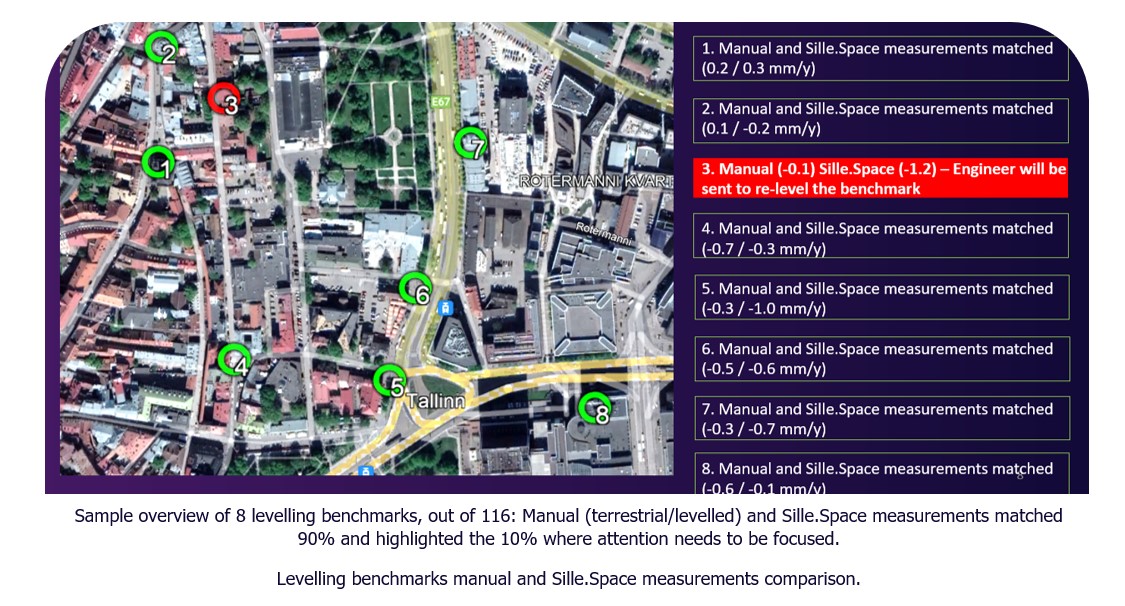
• Manual (terrestrial leveling) and Sille.Space measurements matched 90%
• The focus was to capture the 10% of the official height network that needs re-leveling by engineers. Sille.Space quickly highlighted the areas that need to be focused on and where the leveling benchmarks were outside of the required thresholds.
• Cost saving of a $340,000 if the 116 leveling benchmarks were to be reviewed manually
• Sille.Space has opened a completely new capability to the city’s engineering department and city development office because of Sille.Space is faster, more cost-efficient, and provides frequent historical information. Efficiently monitors a wide area for millimeter movements minimizing survey times and costs
• Regular monitoring of operational infrastructure supports the maintenance program, helping identify possible structural weaknesses or damage, and providing an early warning of possible accelerations in deformation.
Jaanis Lill – Head of Geodesy and Land Management:
“Sille.Space allows the Geodesy and Land Management Unit in Tallinn’s Urban Planning Department to make well-informed decisions about which parts of the height benchmarks need re-leveling. It also enables us to avoid unnecessary and large-scale engineering tasks which in turn also helps to more accurately schedule tasks ahead. – This allows us to save hundreds of thousands in costs.”
Case Studies
Levelling-benchmarks
Use of Sille.space, City of Tallin...
Levelling-benchmarks Tallinn, Estonia Case BackgroundThe complementary use of satellite radar interferometry (InSAR) with traditional systems has be...
Read moreTailings Dam Monitoring
Sille.Space assessments could have...
Newcrest’s Cadia Hill gold mine tailings dam, Australia. Continuing with our case-study series, in 2018, a section of Newcrest’s Cadia Hill gold ...
Read moreUnderground mine
Mining sites, surrounding infrastr...
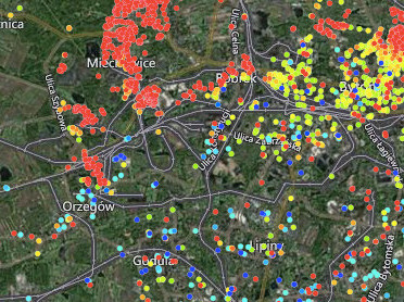
Bytom & Chełm Śląski, Poland Case Background Poland mines millions of tons of coal every year accounting for just over half of the country's ene...
Read moreTunneling Monitoring
Wide area monitoring
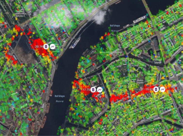
Tunneling monitoring, Saint Petersburg, Russia Case Study BackgroundMonitoring surface deformation to ensure the stability and safety of the undergro...
Read moreLand Subsidence Monitoring
Wide Area monitoring, City, Port,....
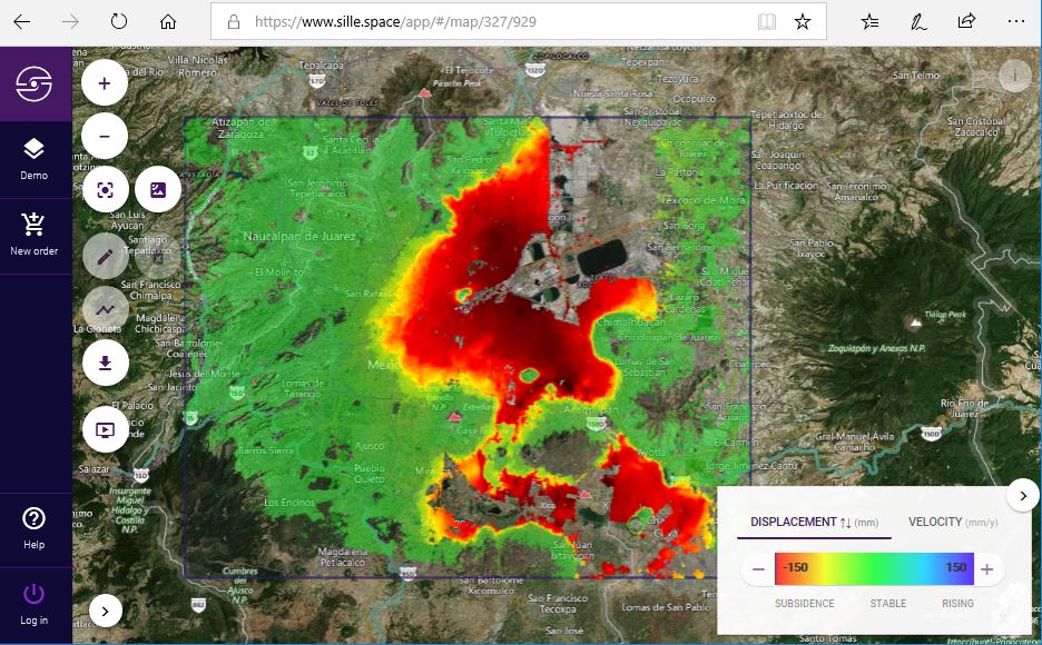
Long-term land subsidence in Mexico City Case Study Background Land subsidence is one of the main hazards in engineering and construction. Urban lan...
Read moreOil Reservoir Monitoring
Oil reservoir deformation monitori...
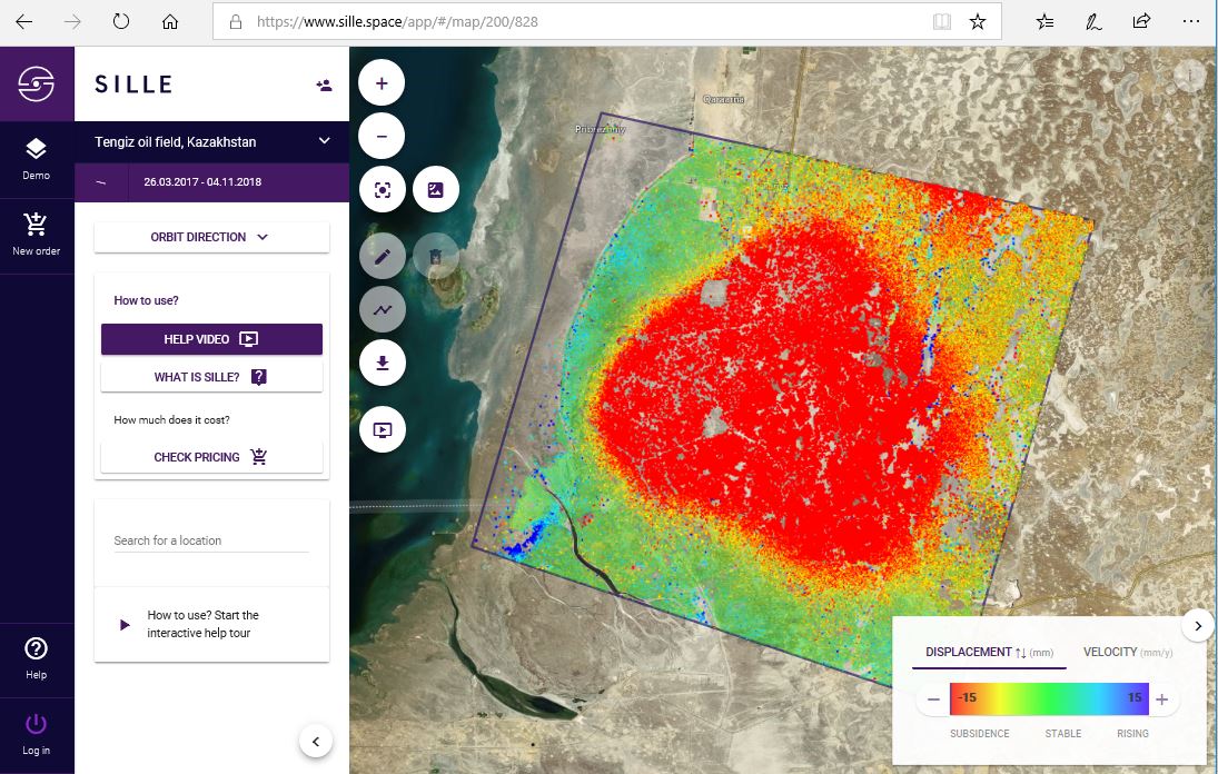
Oil reservoir deformation monitoring in the Tengiz oil field, Kazakhstan. Case Study Background Discovered in 1979, the Tengiz oil field is the sixt...
Read more